Managing Soils in Drought with Confinement Feeding
Preparing for drought should start before the onset of drought conditions. A comprehensive strategy that is flexible to the changing circumstances should be developed.
There are a lot of resources available regarding drought and drought management. The NSW Northern and Southern Drought Hubs provide up to date information on managing drought, business support, and financial services.
A drought strategy or plan for vegetation, soil and stock should include options for
- Stocking rates, ensuring livestock numbers are sustainable with available feed
- Maintaining soil condition, monitoring of pasture and stubble levels
- Animal welfare: storing feed supplies and ensuring the supply and quality of water
Confinement Feeding Areas are areas where stock are confined in either small paddocks or yards for full hand feeding and management during drought conditions. These areas can be sometimes referred to as sacrifice paddocks, drought feedlots or stock management areas. Confinement feeding areas play an important role in addressing the points above, where landholders are reluctant to fully destock.
The main reason for establishing confinement feeding areas is to maintain stock condition and health and relieve pressure on the pastures and soils going into and immediately after drought, by reducing stock numbers and delaying restocking.
Soils and Groundcover
Productive soils underpin sustainable land management and production of pasture and crops, but are most susceptible to degradation and erosion during and immediately after drought. Soils vary in susceptibility to these impacts, according to their texture, structure, organic matter content and fertility (as well as the topography in which they occur and, importantly, their management). Soil damage can have a long-lasting effect on production and will likely be difficult and expensive to repair. So, it is important to know your soils and how they behave. Good soil physical structure with plentiful plant roots (especially grass roots) provides resilience to drought conditions by allowing good infiltration and storage of water that does fall, and prevents the formation of physical soil crusts and provides resistance to compaction and soil loss.
Land condition is a function of vegetation condition and soil condition. Plant biomass is the best indicator of vegetation condition. High biomass also indicates high root biomass, which drives soil organic matter accumulation and soil structure maintenance and improvement. Grasses tend to have a greater effect on soil structure than broadleaf plants including legumes (an exception being large-rooted species like chicory).
Biomass can be measured in the field by clipping and weighing vegetation. Estimates are also available from remote sensing (see the Meat and Live Stock Australia Australian Feedbase Monitor.
However, most research has focused on the link between soil groundcover and soil erosion, so groundcover is the next best measurement.
Groundcover is the amount of plant material (alive or dead) that covers the soil surface. It is expressed as a percentage: 100% groundcover means that the soil cannot be seen, and 0% groundcover is bare soil. High levels of groundcover are the best defence for soils from water and wind erosion. Groundcover also plays a key role in increasing soil structure and aiding water infiltration and water-holding capacity, nutrient retention and microbial activity through increased soil organic matter.
Managing groundcover to protect the soil and maintain the input of biomass from root growth to maintain fertility should be a key aim of land management.
The minimum amount of groundcover required to prevent excessive runoff and water erosion varies with rainfall amount, intensity and seasonality, soil moisture level, slope gradient and length, and soil properties. It ranges from 100% of steep lands to 70% on gentle sloping country to 40% on the plains and rangelands (Lang and McDonald 2005). For wind erosion control 50% is required, with standing vegetation or crop stubble most effective (Leys 1999)
It is important to continually monitor the total cover amount, i.e., of living and dead vegetation. Cover levels decline most in dry times, generally due to the failure of growth during the winter growing season.
Cover monitoring can be by satellite and/or on-ground.
Satellite monitoring of vegetation cover
Remote sensing of vegetation cover by satellite is now routinely available via various websites (Guerschman et al. 2018; Leys et al. 2020). One website, funded by CSIRO and the National Landcare Program, provides free data and maps, is RaPP Map.
This site provides monthly maps of:
- Total vegetation cover, i.e., live (green) plus dead (non-green) vegetation. Click this link for an example of total vegetation cover for November 2025. Click “Continue”, then drag the symbol left and right to see the cover map or the underlying satellite image; see Figure 1.
- Fractional cover, i.e., green, non-green and bare ground. Click this link for an example of fractional cover; see Figure 2.
- Time series of rainfall, live, dead, bare ground and total cover. Click this link for written help or this link for a video on how to get time series from RaPP Map.
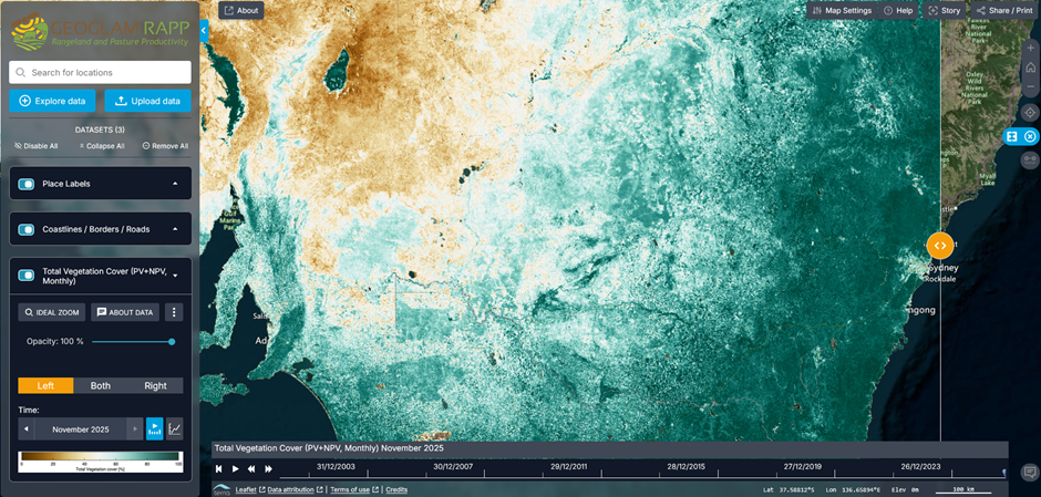
Figure 1. Total vegetation cover map for November 2025. A is low cover 12%, B is high cover 98%; and C is a fire scar with 19% cover. D is the time slider.
Figure 1 shows the total vegetation cover distribution for November 2025, where brown colours are low cover and blue colours are high cover. Areas coloured brown are at risk of wind erosion. Areas coloured light blue or darker are protected from water erosion. By moving the time slider, “D” in Figure 1, different monthly dates are displayed.
Figure 2 shows the fractional cover map for November 2025. “A” is near Orange and shows the cover is green vegetation, i.e. green tones. “B” is west of Henty and shows a very high proportion of non-green vegetation. “C” is east of Lake Frome and shows a very high proportion of bare ground cover.
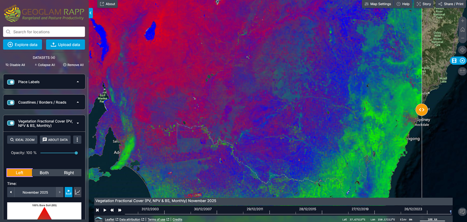
Figure 2. Fractional cover map showing: A) live (photosynthetic vegetation PV), B) dead (non-photosynthetic vegetation NPV), and C) bare soil (BS)
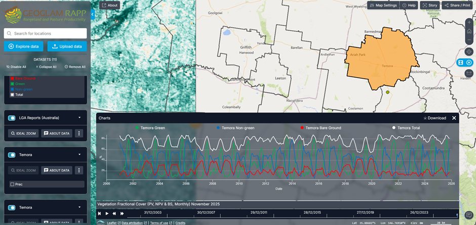
Figure 3. Time series for Temora LGA of green, non-green, bare ground and total vegetation cover
Figure 3 shows the time series for Temora LGA. The total cover curve (white line) ranges from 90% to 55%. For this LGA, a cover of about 80% in September is required if the March ground cover is to be above 60%.
Groundcover can be assessed in the paddock using several simple methods:
Step-pointing method
- Make a 1mm wide mark on the toe of each boot
- Walk across the paddock in the area you wish to assess. Walk in a straight line, taking equally spaced steps
- Take 100 steps, or more preferably
- At each step, record the occurrence of bare ground or cover directly below the mark. If required, the cover can be recorded as perennial, annual or litter
- Calculate the percentage cover (or bare ground).
- Repeat in different parts of the paddock
Wire point method
- Walk across the paddock in a straight line
- At each step, hold a 1-metre length of fencing wire vertically to the ground from the outstretched arm (without looking)
- Record the type of contact: bare ground or cover for 100+ steps
- Repeat in other parts of the paddock
- Calculate the percentages of cover and bare ground
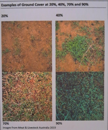
Quadrats
- Make a square quadrat 50x50cm from wire, thin steel rod or wood
- Throw the quadrat at random at 50-100 places in a paddock
- In each, estimate the percentage of cover or bare ground
- There are standard photos available to guide estimates, e.g. the pictures below, and Walker (1992)
Drones
- Huge potential, probably not fully recognised as yet.
Groundcover assessments done progressively over time will provide a guide to changes that may not be apparent to the eye, and benchmarks should be chosen to trigger destocking. An example of this is if the cover is below 70% in the growing season, then destocking may be required if the cover is to be maintained above 50% in the following autumn.
Photographs from fixed points are another great tool for comparing groundcover levels over a long period of time
A decision must then be made on which paddocks should be destocked first. This will be determined by the groundcover levels, the landscape, the soil type, the pasture type and management logistics.
The soil types most susceptible to wind erosion during drought are those with sandy topsoils (lighter than loams) or soils that have been finely cultivated or trampled by stock. Rain events do occur during drought, with light to medium textured bare soils most susceptible to water erosion, particularly those on steep slopes or long low slopes not protected by contour banks. These rain events also cause surface crusting of bare disturbed soils low in organic matter, reducing infiltration rates of subsequent events, reducing moisture storage, and further increasing the risk of water erosion.
Annual pasture cover will likely decrease faster than perennial pasture, especially if continually grazed and trampled. Paddocks with mainly annual pastures require vigilance for destocking action, especially those on sandy to loamy soil. However, pastures with a high proportion of perennial species, and especially grasses and chenopod shrubs, will provide longer-term groundcover and protection of soils, especially when residual sub-soil moisture remains. Still, it is critical that the grass butts are not eaten into the ground so that they can respond rapidly when it does rain again.
Available water supply may also be a limiting factor, but it is important to avoid in-paddock feeding after the trigger point has been reached just because a water supply remains, unless in desperate water supply circumstances elsewhere on the property.
Stock Confinement Areas
may vary in size from yards up to holding paddocks, existing or newly constructed. They become, in effect, sacrifice areas, so avoid siting them on valuable pastures or erodible soils. However, they can and should be rehabilitated after use (unless retained for ongoing stock feeding, holding or management).
Site selection is well covered in the publication A Guide to Confinement Feeding Sheep and Cattle in NSW to be found on the Central Tablelands Local Lands Services website.
Soils with well graded particle sizes can best resist compaction: they tend to be coherent and strong across a range of moisture contents and resist water and wind erosion. Ideal soils would be sandy clay loams, loams and clay loams, with some gravel component a bonus. To assist with soil type assessment, there are Soil Landscape maps and a large number of data sites across the state on eSpade (found on the website espade.environment.nsw.gov.au or just Google it: and on the righthand side of the first page check Soil Profiles and Soil Landscapes (the latter cover only part of the state), and there are soil texture maps for topsoil and subsoil at fixed sampled sites)
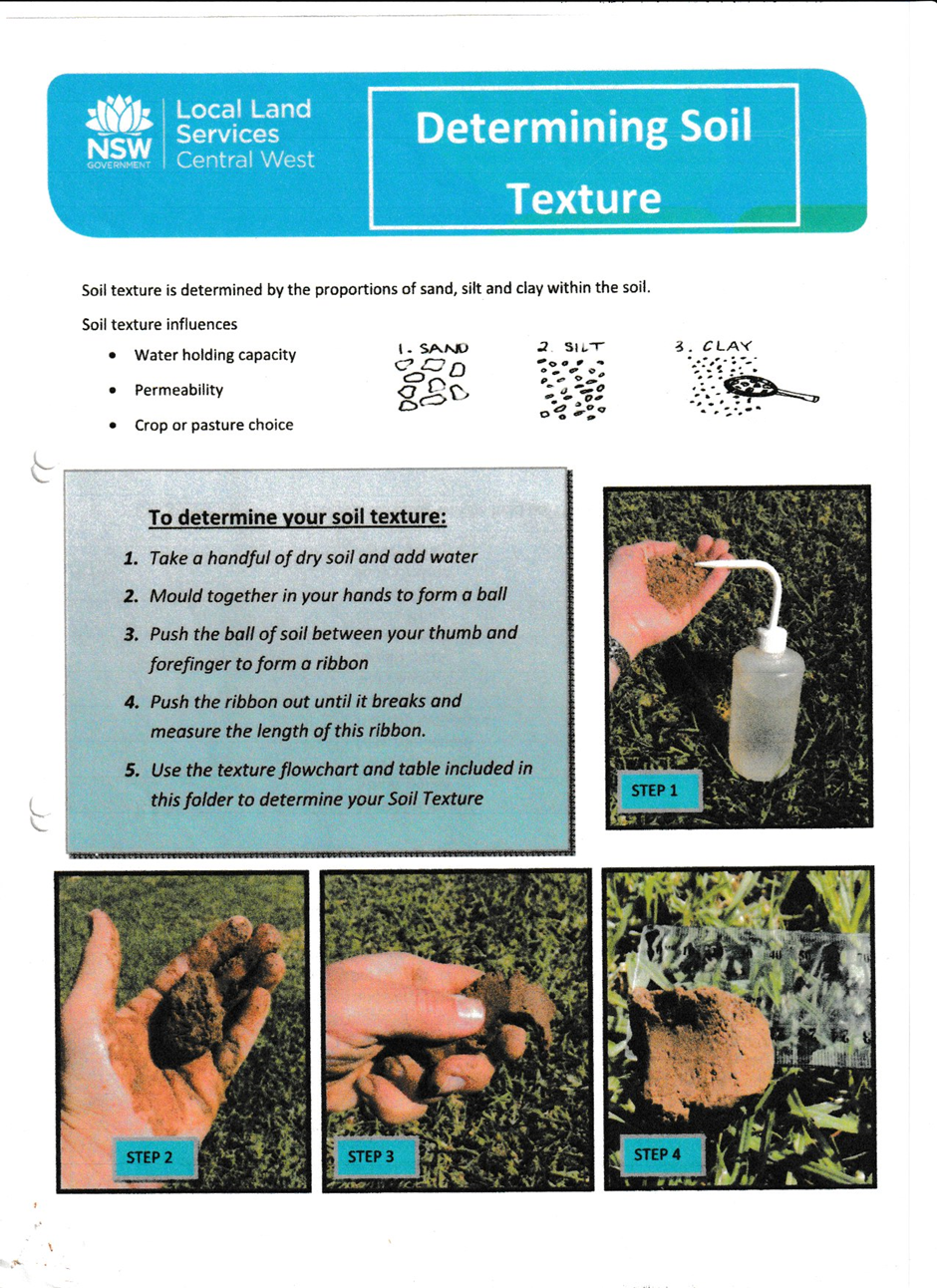
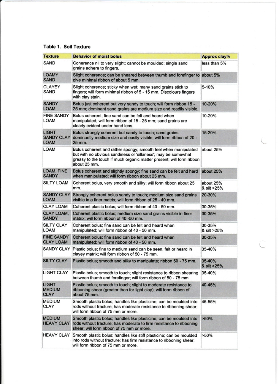
Soil surface texture can be easily estimated by working a handful of soil and comparing the feel with a soil texture table (attached), ranging from sands through loams and clay loams to clays. It is well to also assess the texture of the subsoil, say about 30cm depth, as clays or hardpans will restrict drainage and result in boggy conditions after rain. On the other hand, sandy subsoils allow deep penetration of nutrient rich water.
The site should be located on a gentle convex slope (or gentle spur) and protected by a contour or diversion bank to prevent runoff across it. High stocking density with high nutrient stock feeds going into a small area for a prolonged period will lead to very high nutrient runoff. Such runoff can greatly impact water quality if allowed to run into drainage lines at the end of the drought. Runoff needs to be diverted into a tank (dam) not connected to a drainage line. On long low slopes an alternative is a diversion-spreader bank below, to draw off any runoff water from the site. Spreader banks (where after reaching a suitable grassy area, the bank is pushed on the up side of the channel and a level sill is created on the lower edge of the channel) spill the water gently and provide an irrigation of the area below.
Confinement should continue after drought-braking rains, until pastures have recovered (outlined in Drought Recovery Guide DPI 2020, droughthub.nsw.gov.au ). If the confinement area is temporary, rehabilitation can be undertaken post drought. The soil surface will likely be bare, compacted, and pulverised by hoofs. The surface may need to be cultivated or ripped, and sown with a cover crop or pasture. The plant nutrient content of the soil will most likely have been increased by stock excrement (and may end up being one of the most fertile areas on the property), but there may be an imbalance, and acidification may be a problem. Soil testing is advised. The area may also become infested with high nutrient-using weeds, which will also need to be managed. The dam or tank used to catch runoff should be desilted if necessary and the spoil spread elsewhere.
Some landholders in the Central West have established plantations of oldman saltbush in small paddocks to provide drought feed. Saltbush should not be continually grazed and needs a recovery period. It provides an alternative maintenance ration well into drought and is another form of stock confinement area.
Emergency Soil Conservation Measures
If a soil erosion hazard arises in the destocked paddocks during drought, a number of emergency measures can be used.
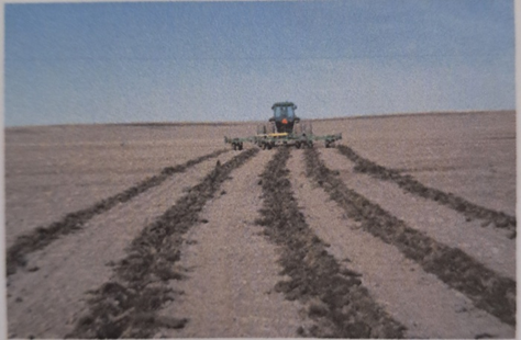
If cropping land or grazing land that is capable of cultivation begins to blow, roughening of the surface with a chisel plough or ripper will reduce wind erosion, but only if the soil contains enough clayey material to allow clods to be brought to the surface. There is no point bringing up small loose particles as these merely provide more material to blow. The ploughing should be carried out at right angles to the prevailing wind direction on flat paddocks and, where possible, on the contour on sloping paddocks to also give some protection from the next rain.
Use wider than normal tyne spacings, i.e., remove every second and third tyne so that metre-wide strips are between ploughed lines. Also, use a slow speed (5kph) to reduce damage to soil structure and breaking up of clods.
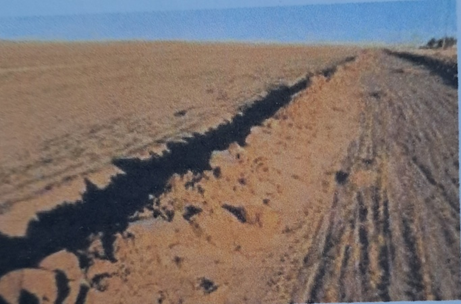
In desperate times on sandy soils, wind ridging can be used. This involves forming low ridges (or banks) of soil about 30cm high and 3m apart at right angles to the wind direction, using a delver with a ripper point or a modified blade plough with a grader blade. This practice is only recommended if it brings up clods; otherwise it too only produces more sand to blow.
To reduce water erosion, contour furrowing is a low cost, rapid option on grazing or cropping lands. Furrows are constructed with a mouldboard plough, disc plough or grader, following the contour as near as possible and from 10 to 20 metres apart, depending on slope and soil type (or 5 metres if wind erosion is also a hazard). These will trap water, silt and seeds and provide areas for rapid pasture growth after it rains. These will continue to have benefits in the longer term unless they fill with silt.
In areas with severe problems, full-scale soil conservation earthworks would be invaluable.
References and Further Reading
Anon (2022) Drought Recovery Guide. NSW Department of Planning, Industry and Environment (droughthub.nsw.gov.au)
Central Tablelands Local Lands Service (2023) A Guide to Confinement Feeding Sheep and Cattle in NSW. Central Tablelands LLS website
Guerschman, J.P., and Hill, M.J. (2018). Calibration and validation of the Australian fractional cover product for MODIS collection 6. Remote sensing letters 9(7), 696-705. doi:10.1080/2150704X.2018.1465611
Lang, R.D., and McDonald, W. (2005). ‘Maintaining groundcover to reduce erosion and sustain production, Agfact P2.1.14’. NGDoP Industries. Available at: https://www.dpi.nsw.gov.au/agriculture/pastures-and-rangelands/establishment-mgmt/production-management2/groundcover [accessed.
Leys, J.F. (1999). Wind erosion on agricultural land. In ‘Aeolian Environments, Sediments and Landforms.’ (Ed. AS Goudie, I Livingston and S Stokes) pp. 143-166. (John Wiley and Sons: England)
Leys, J.F., Howorth, J.E., Guerschman, J.P., B., B., and Stewart, J.B. (2020). ‘Setting targets for National Landcare Program monitoring and reporting vegetation cover for Australia ‘. Department of Planning Industry and Environment, Sydney. Available at: https://www.environment.nsw.gov.au/research-and-publications/publications-search/setting-targets-national-landcare-program-monitoring-reporting-vegetation-cover-for-australia [accessed.
Walker PJ (1992) Managing for Drought. CALM Technical Paper 1. NSW Department of Conservation and Land Management (Available on-line at TROVE website)
Young Mary-Anne et al. (2022) Managing Soils During and After Drought in Grazing Systems. Soil CRC Fact Sheet
Young Mary-Anne et al. (2022) Managing Soils During and After Drought in Cropping Systems. Soil CRC Fact Sheet